Lake Waikaremoana Great Walk
The Lake Waikaremoana Great Walk is a 44 kilometre tramping track which follows the southern and western coast of Lake Waikaremoana in the North Island. Passing through several types of forest, and grassland, track often provides excellent views over the lake. The Lake Waikaremoana track has the largest area of native forest in the North Island.Lake Waikaremoana was formed 2200 years ago by a huge landslide from the Ngamoko Range, which blocked a narrow gorge along the Waikaretaheke River. Water backed up behind this landslide to form a lake up to 248 metres deep. In 1946 a hydroelectric development lowered the lake level by 5 metres.
Lake Waikaremoana Great Walk有茂密森林以及不錯的湖景 湖灣 但較Milford Track and Routeburn Track則略為遜色

Starting from Onepoto Bay shelter, the track then climbs steeply up onto Panekire Bluff. The bluffs provide spectacular views over the expanse of the lake. Following the ridge, the trail has several sharp dips and climbs. Panekire Hut sits in a small clearing next to the Panekire Trig point (1180m), at the top of the cliffline, with excellent views of the lake.
The trail from Panekire Hut goes west, climbing and descending over the Panekire Range, before eventually descending precipitously into much taller and wetter forest. At the end of the descent lies Waiopaoa Hut, on the edge of the Waiopaoa Inlet part of the lake.
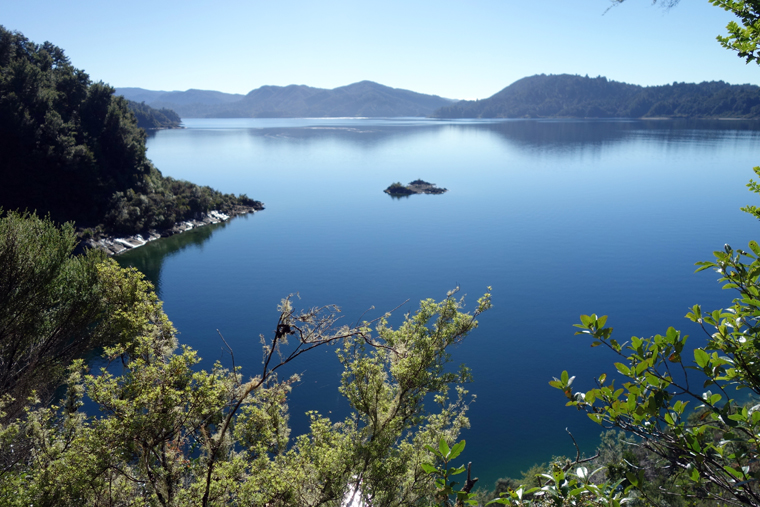
Lake Waikaremoana Great Walk是一四天行程 James為縮短成為三天的行程 因此第一天蠻辛苦 有引入的森林景觀 由於大霧 應有極好的湖景 但完全看不到

starting from Onepoto Bay shelter

quite even at the beginning

dense mist

undulating and steep


Forest on the Panekiri Range

Trig (618m)

Panekiri Bluff
On a fine day this would be a superb lookout with fine views of the lake. Unfortunately dense mist prevented from appreciating them.

High altitude forest in mist

walking along cliff edge

very undulating

on Bald Knob
Should be very distinctive rocks but looks unclear!

long step up

lots of view points

Trig (1180m) nearby Panekire Hut

Panekire Hut, built on top of Puketapu, one of the highest points in the Panekiri Range.

walking along cliff edge


long step down

distinctive cliff edge

distinctive tree

Waiopaoa Hut
Waiopaoa hut was built mid 2006 and has a lovely look and feel. The log burner certainly heats up the hut more than a gas heater would and gives the place a great atmosphere. 30個鋪位 只有6個人 因此睡的非常香甜Day 2 Waiopaoa Hut to Waiharuru Hut (total time 7.5 Hours)
Head up the Waiopaoa Stream a short distance before crossing grassy flats and heading through kānuka forest on the lake shore. The track, while undulating, weaves its way through rimu wooded areas and along the lake edge to Marauiti Hut. Take a short walk (1 hour return) up the side track from Korokoro Campsite to the beautiful Korokoro Falls. Continue to Waiharuru Hut after taking a walk to cross the edge of Puketukutuku Peninsula, kiwi sanctuary.

stunning scenes nearby the Waiopaoa Hut in the early morning


bridge over Waiopaoa stream

beautiful reflection viewing from the bridge

grassy flats

beautiful forest

lots of attractive scenes on the side walk to the Korokoro Falls


negotiating wire to cross over Korokoroowhaitiri Stream


stunning 22m high Korokoro Falls

turning back main track

The track leads past a number of small bays cutting across a couple of points.


Marauiti Bay

looking back the Marauiti hut


Waiharuru Hut
Waiharuru looked more like a bush lodge than a tramping hut. it's new upgraded with gas heater and kitchen area and bedding area separated. 40 bedding spaces.

viewing from the hut front side

viewing from the hut rear side

beautiful scenes nearby


a beach good for swimming
(total time:6 hours, water taxi pick up time 2 pm)
Waiharuru Hut, the track climbs over the Pukehou ridge following the kiwi exclosure fence line all the way down to Tapuaenui Campsite. Then the track meanders along the lake shore and forest to the Whanganui Hut. The water taxi pick up from the lake side of Whanganui Hut. To finish of the whole Lake Waikaremoana Great Walk, James walks to the Hopuruahine Landing, the original water taxi pick up point, and return through the alternate route to Whanganui Hut.


rock surface terrain


shortly arriving at Puketukutuku Peninsula kiwi sanctuary

kiwi sanctuary predator proof fence


then the scenes is general on the way to the Whanganui Hut


Whanganui Hut

crossing a bridge and heading to Hopuruahine Landing

waterfalls nearby the bridge

following the original route to the Hopuruahine Landing

beautiful scenes

spectacular cliff scenes
DOC built an alternate route because of cliff landslide


stunning scenes


Huiarau bridge


Hopuruahine Landing

returning through alternate route

some good views on the alternate route

taking water taxi back to the Waikaremoana Holiday Park
some good scenes from water taxi
